If you are interested in how the city of Zurich has developed over the last 5,000 years, you can now look it up online. The city of Zurich writes about the new service: “The web application “Zurich 4D” makes the structural development of the city from the Neolithic period to the medium-term future publicly accessible and shows various time periods as digital 3D city models.
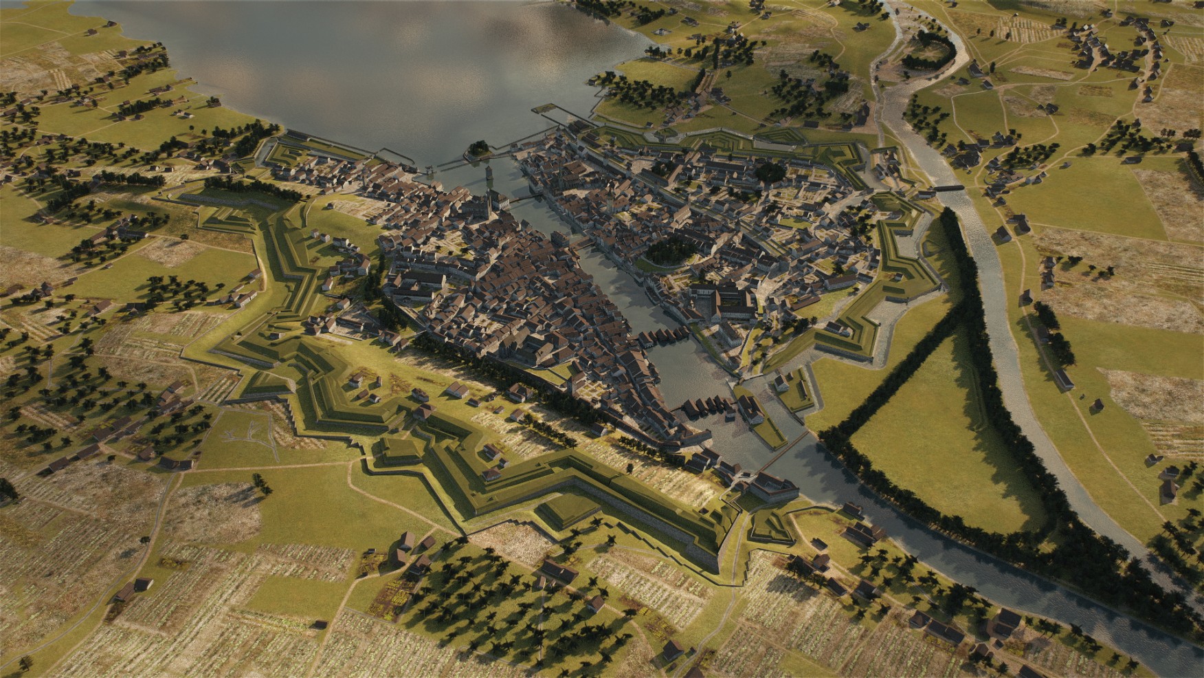
In addition to the previously published sections from around 3000 BC and 1800, there is now a new 3D model showing the city around the year 1500. Interested visitors can immerse themselves in late medieval Zurich, when the old town, with just under 6,000 inhabitants, took on its current form: the first closed rows of houses line the alleyways, the high residential towers of wealthy families such as the Grimmenturm on Neumarkt characterise the cityscape with their typical architectural form. Next to the town hall, you can also recognise the former vegetable bridge, the actual “marketplace” of Zurich, and the wooden pedestrian footbridge upstream, which was to become the cathedral bridge around 300 years later. In the villages outside the city, there are mainly wooden buildings and the landscape is characterised by meadows, fields and wooded hilltops.”
Fly over Zurich around 1500 as a video animation (source: Stadt Zürich, Amt für Städetbau)
The data sources for the digital models were the results of architectural archaeological investigations and historical image documents. “The altarpiece by Hans Leu was the most important source of images for the reconstruction of the old town around 1500. It shows the city saints Felix and Regula in front of a very detailed panoramic view of the city of Zurich,” says Stephan Wyss, Head of Stadtarchäologie beim Amt für Städtebau.

Zurich around 1500, view to the south-west. In the foreground on the left is the preacher’s monastery, of which the church still stands today. Visualisation: Stadt Zürich, Amt für Städtebau
Zürich 4D” was developed by the GIS-GIS-Kompetenzzentrum des Hochbaudepartements in collaboration with Geomatik + Vermessung (GeoZ). The data basis is the 3D city model. The most popular freely accessible geodata set of the city of Zurich can now be easily visualised virtually. The numerous visualisation and analysis options allow users to work at different scales – from a city-wide view to a detailed building model, as the city of Zurich writes. Further views – known as digital 3D city models – are planned by the end of 2026 as part of a pioneering scientific and technical project.
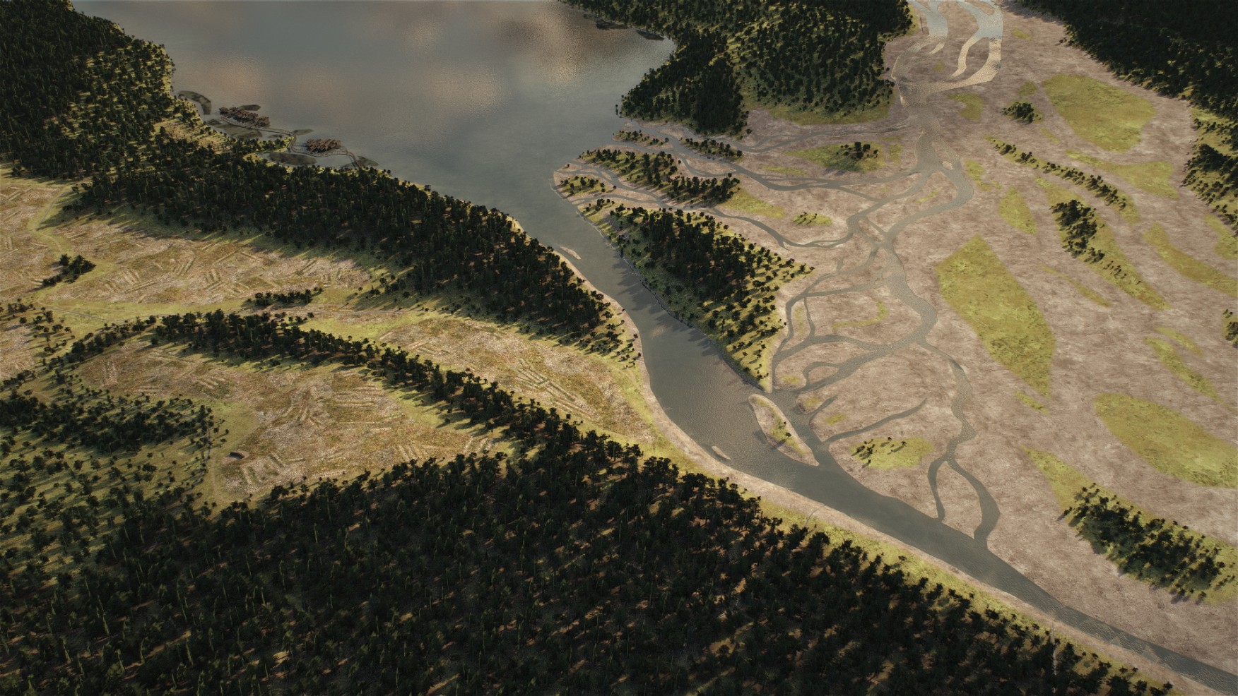
The settlement of Zurich at the time of the Neolithic lakeside settlements at the end of the 4th millennium BC is characterised by short-lived villages, which often moved their locations a few hundred metres along the shore. Sometimes there were even several within sight of each other. The capital of the people was the intensively cultivated landscape with orchards, cyclically intensively utilised tree stands, hedges, fields, fallow land and the trees cut down to produce hay. Quelle: Stadt Zürich, Amt für Städtebau

The time slice “Zurich around 1500” allows you to discover the city in its late medieval state, when the Old Town, with just 5000-6000 inhabitants, took on its current form: the first closed rows of houses line the alleys, the high residential towers of wealthy families such as the Grimmenturm on Neumarkt characterise the cityscape with their typical architectural form. Next to the town hall, you can also recognise the former vegetable bridge, the actual “marketplace” of Zurich, and the wooden pedestrian footbridge upstream, which was to become the cathedral bridge around 300 years later. The villages outside the city are mainly characterised by wooden buildings. The landscape is characterised by meadows, fields and wooded hilltops. Quelle: Stadt Zürich, Amt für Städtebau
Around 1800, the city of Zurich is characterised by the Baroque fortifications that surround the medieval city centre and its walls in a star shape. The Fraumünster Abbey and the city’s other monasteries are still intact as building complexes. In the newly developed area between the old town and the Schanzen, the early industrial textile industry has settled. At the same time, this is where the elegant residential buildings of the owner families are located. The suburbs of Zurich, which were incorporated in 1893 and 1934, are still small, rural villages. Quelle: Stadt Zürich, Amt für Städtebau